


UPDATE: Sept. 18 8:00 p.m.: Recent rain has helped Creek Fire efforts, but will be short lived
Creek Fire containment continues to rise, now reaching 22% contained with 248,296 acreage burned.
The U.S. Forest Service (USFS) warns in its Sept. 18 incident update that due to down-sloping winds and an inversion layer, smoke will be present in areas of lower elevations and valleys this weekend.
The incident report also made note of the closure of the Yosemite, Sequoia and Kings National Parks due to the unhealthy air quality conditions due to smoke.
The USFS made sure to report that the park’s closure was solely due to unhealthy air conditions and not due to the threat of the fire spreading.
As stated in previous briefings, preparations are continuously being made in an effort to mediate any damage to Mammoth Lakes as winds push the Creek Fire into the northeast.
Management Action Points (MAPs) have been set and if the fire is to cross any of these MAPs near Mammoth Lakes, emergency officials will act appropriately to the situation at hand to mitigate damage.
Two major turning points in the Sept. 18 briefing were the lifting of various evacuation orders and warnings in the North and South zones.
Lt. Kathy Curtice of the Fresno County Sheriff’s Office (FSO) reported that nine evacuation zones turned into warnings and fifteen additional evacuation warnings were lifted today.
“We are making steady progress in reducing those orders and lifting those warnings and we really appreciate the public’s patience as we go through this process. Public safety really is the most important part of this process for us,” Curtice said.
Sgt. Joseph Wilder of the Madera County Sheriff’s Office also reported some good news stating a few evacuation warnings were lifted.
These areas can be found here.
Incident Meteorologist Matt Mehle said during the briefing that the storm system off the coast put some much needed moisture into the air allowing for scattered showers to fall over the Creek Fire for most of the day.
Although there has been rain, Cal Fire’s Fire Behavior Analyst Don Watt said they are expect warmer temperatures and weather trends this upcoming week. Knowing this, firefighters remain on guard for an increase in fire activity as weather patterns continue to change.
Re-population efforts can be found in the FSO Creek Fire news release available on their Facebook page.
UPDATE: Sept. 17 9:44 p.m.
As of Thursday evening, Cal Fire reported that the containment is at 20%.
There has been success in containing the fire north, near Cascadel Woods.
The total acreage burned is now 246, 756; posing a threat to approximately 8,561 structures. 783 structures have been destroyed and 67 structures have been damaged.
It was reported that there was expected to be rainfall in the areas that are being affected, ranging from Mammoth Lakes to Fresno.
UPDATE: Sept. 16 at 8:32 p.m.:
Firefighters battling the Creek Fire have begun preparations for a dramatic weather change as the fire area’s high-pressure system begins to move east.
With a low pressure-system moving over California during the next week, weather reports state cooler temperatures, clear air and turbulent winds will occur at higher elevations.
These new conditions give the Creek Fire a chance to become more active and affect the fire’s current fireline. This weather change was noted by Fire Behavior Analyst Tobin Kelley and Incident Meteorologist Jim Wallmann.
As of now, flames have remained at low intensity, but because not all of the land’s vegetation has been consumed. As winds increase, the intensity of the fire is suspected to grow as it’s pushed closer towards these lines.
Knowing this, firefighters have been working adamantly to improve containment lines and various shaded fuel breaks to stop and deflect the fire from spreading.
During the Sept. 16 briefing, Fresno County Administrative Officer Jean Rousseau explained as winter approaches evacuations may be common due to increased flooding and debris flow from the fire. He mentioned this as a “heads up” to the public to prepare them for this potential situation.
Another major concern during the briefing was the protection of Mammoth from the Creek Fire.
Cal Fire said it is doing what it can to mitigate damage if the fire makes its way into this area. As stated in tonight’s briefing, this zone is being secured and prepped by placing trigger and management action points to mediate this threat.
Wallmann also reported that a red flag warning will be issued Sept. 17 until Saturday, Sept. 19, due to the strong gusts of wind that may potentially cause the fire to move into this area.
Another large focus of the livestream was stated by Incident Cmdr. Marty Adell who informed the public that the Creek Fire team is awaiting military assistance which is set to arrive Sept. 19 and 20.
A total of 230 marines and 2o corpsmen will arrive on scene and train for two days with firefighters to prepare for various operations given once the group is deployed to the north and south zones of the fire.
The Creek Fire has now damaged around 228,000 acres at 18% containment with over 2,800 personnel assigned to the incident.
UPDATE: Sept. 15 10:47 p.m.: VP nominee Harris gets briefed on Creek Fire, talks climate change
California Senator and Democratic Vice President Nominee Kamala Harris joined California Governor Gavin Newsom at Pine Ridge Elementary School for a briefing on the Creek Fire, on Tuesday afternoon.
Harris planned a visit to the Central Valley for “an assessment of the wildfires,” landing in at the Fresno Yosemite International Airport, according to Fresno Bee reporter Brianna Calix on Twitter.
Newsom joined her for what was his second time visiting the Creek Fire aftermath this week.
The vice presidential nominee took to Twitter amid the briefing to advocate for climate change.
“The historic wildfire season in the west and record-breaking hurricane season in the Atlantic are not a coincidence. This is climate change,” Harris said.
Later tweeting, “The climate crisis is an existential threat and a fundamental challenge of our time. RT if you agree.”
Harris and Newsom later visited Fresno State nursing students volunteering with the Red Cross at Clovis North High School.
“I was fangirling so hard,” Fresno State nursing student Alexis Macedo said. “It was the highlight of my week.”
U.S. Forest Service – Sierra National Forest hosted a Zoom call in place of their daily briefing at 7 p.m. on Tuesday.
In the briefings, it was reported that the fire containment has risen to 18%. The damage now includes over 344 square miles burned and 632 structures destroyed, 19 of which are homes.
Mammoth Lakes Fire Protection District joined the Zoom meeting to answer questions about the suspected evacuation of the town of Mammoth Lakes. As of now, the Town of Mammoth Lakes will not be evacuated, but will be closely watched.
Regular briefings on the Sierra National Forest Facebook will resume Wednesday at 7 p.m.
UPDATE: Sept. 14 9:08 p.m.: Creek Fire has reached 16% containment
The Creek Fire has now burned a total of 212, 744 acres and has reached 16% containment.
Fresno County Chief Administrative Officer Jean Rousseau said a damage assessment webpage has been created in partnership with Cal Fire, which is located on the County of Fresno’s webpage.
This webpage is helpful for those who are worried about the damage their homes and cabins may have faced due to the Creek Fire.
According to Rousseau, the animals recovered during the fire have been sheltered at Granite Ridge Intermediate, the Clovis Rodeo grounds and the Fresno Fairgrounds.
Lt. Ryan Gilbert of the Fresno County Sheriff’s Office stated that seven zones were changed from evacuation orders to evacuation warnings as of today. These zones include F5L, F5M, F5N, F6A, F13C, F13D and F13E.
Summaries of each zone can be found here.
Madera County Sheriff Cmdr. Bill Ward announced some changes to evacuation orders and warnings, stating the south side of Bass Lake, Teaford Meadows and North Fork, have moved from evacuative orders to warnings.
Orders have been lifted from Oakhurst and the 41 Corridor down to Rd. 200, Ward said.
Denise Tolmie, District Ranger for the Bass Lake District at the Sierra National Forest, said the order for the closure of the Sierra National Forest in the southwest region of California will be extended.
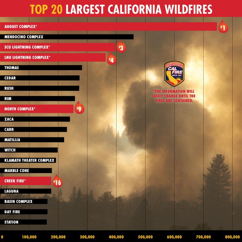
Cal Fire Incident Cmdr. Nick Traux said the Creek fire is now ranked at No. 13 on the largest fires in California history.
Forty-six percent of damage inspection has been completed with a total of 47 structures damaged and 555 destroyed, Truax said.
UPDATE: Sept. 12, 8:02 p.m.: Air quality advisor warns of pollutants caused by Creek Fire
The Creek Fire has now burned a total of 196,667 acres. Fire containment has increased to 8% with roughly 2,301 personnel on the fire fighting team.
Julie Hunter, air quality advisor for the Creek Fire, warned the public about a primary pollutant created by the smoke known as particulate matter. When suspended in the air, it can travel deep into our lungs and even into our bloodstream if one is exposed to it for a period of time.
Hunter encouraged the public to remain cautious, especially sensitive groups such as those with heart and lung disease.
Incident Cmdr. Marty Adell, spoke on weather conditions stating that Cal Fire will focus on monitoring wind changes, speed and direction the next few days.
Adell continued by saying that these new wind patterns will clear out some of the smoke in the area which can be seen as both a positive and negative.
Smoke clearance grants aircrafts the ability to see, but it also causes an increase in heat leading to a potential increase in fire activity.
Adell also asked the public to refrain from flying drones into the fire area due to a recent drone inclusion.
“We understand why people want to use it [the drones],” Adell said. “But the big point that we are really trying to make is…if someone flies [a drone], we can’t.”
As stated towards the end of the livestream there will be no briefing tomorrow night, but they will continue again starting Monday, Sept. 14.
UPDATE: 9:02 p.m.: Friday night sees small acreage increase as smoke cools temperature
As of Friday night’s briefing, a total of 182,225 acres has been burned due to the Creek Fire and containment remains at 6%.
Forest Supervisor and Agency Administrator Dean Gould stated that this is the first time since the fire began that the acreage burned was less than 10,000.
“Yet another great milestone that we can appreciate in terms of trends,” Gould said.
Incident Meteorologist Matt Mehle was later introduced and stated that although the smoke has caused unhealthy air levels to rise, it has kept temperatures cool causing the fire’s growth to happen at a much smaller rate.
Mehle said smoke has also kept the winds in check for the past few days which has also helped slow the spread of the fire.
He continued that warmer temperatures are in store for the upcoming weekend, but predicts that throughout the week there will be cooler temperatures.
Cal Fire Incident Cmdr. Nick Truax stated that the Creek Fire is now No. 16 on the top 20 fires that have burned in the state of California.
Truax says that 17% of damaged buildings have been validated and that approximately 4,900 structures are still needing inspection.
UPDATE: Sept. 11, 10:19 a.m.: Creek Fire moves into the Top 20 largest wildfires in California history
Although containment numbers are rising, the Creek Fire has cemented itself in California history as one of the largest fires of all-time. Cal Fire says that the fire is currently the 17th largest wildfire in the state’s history.
The 2020 fire season continues to be record-breaking as over 3 million acres burned across California. The Creek Fire joins the August Complex, SCU Lightning Complex, LNU Lightning Complex, Elkhorn, North Complex in the Top 20 list.
On Thursday, the August Complex fire became the largest at 471,185 acres. Cal Fire announced on Friday that the fire has merged with the Elkhorn fire and several other fires now covering 746,607 acres with 25% containment.
The SCU Lightning fire sits at No. 3 on the list reaching 396,624 acres and is near full containment at 98%. The LNU Lightning Complex is right behind in the No.4 spot at 363,220 acres and 95% contained.
UPDATE: 7 p.m.: Containment Reaches 6%, Hours After a Reported 0%
Thursday evening’s Creek Fire Incident Briefing reported that the fires have been 6% contained. This comes nine short hours after a report that stating the containment remained at 0%.
Most of the containment is surrounding Redinger Lake; from Castle Peak to Redinger Campground.
The amount of acreage burned remains at 175,893, announced Public Information Officer Jennifer Myslivy. A total of 361 structures have been destroyed.
Lt. Brandon Purcell of the Fresno County Sheriff’s Department reassured that all evacuations are still in place, as is every warning. While Oakhurst is wary of being evacuated next.
Purcell continued by explaining the context of the explosion that occurred Wednesday night at China Peak Ski Resort. “There is a known facility that stores explosives for avalanche equipment,” Purcell said, “ We were aware of that and due to the fire, there was an explosion.”
Purcell confirmed that there were no injuries and that they are making efforts to better store the equipment.
UPDATE: Sep. 10, 10:19 a.m.: Amount of structures threatened grows to 14,074 as fire continues to rise
For the sixth straight day the Creek Fire has risen in acreage, reaching 175,893 acres affected, while containment remains at 0%.
The number of structures threatened by the fire has nearly tripled from yesterday. As of Sept. 10 the number of structures being threatened has grown from 5,296 to 14,074.
In Fresno County, the southern fire flank from Davis Mountain to the San Joaquin River, firefighters are monitoring spotting as down-canyon winds develop.
Near Shaver Lake, Cal Fire says that there is potential for the fire to spread further east and south. As the fire inversion lifts and clears, aircrafts will be able to be used more extensively.
A fire inversion is when warm air caps cooler air, causing smoke to become trapped in valley bottoms at night and in the early morning.
As for structures in the area, damage inspections and validating and categorizing of damaged and destroyed structures are ongoing as long as fire suppression efforts allow.
Cal Fire says that assessments are approximately five percent complete. For structures damaged and destroyed, single residence structures are listed six are damaged and 60 destroyed, mixed commercial/residential stand at 277 destroyed, nonresidential and commercial structures are at two damaged and 4 destroyed and other minor structures are at one damaged and 20 destroyed.
In Madera County, firefighters are taking advantage of a thick smoke layer that is moderating fire activity on the western flank. This is allowing firefighters the ability to make progress on developing containment lines and the protection of structures.
Crews are extending the containment line from the San Joaquin River to Castle Peak. And near Cascadel Woods, crews are incorporating natural fire breaks.
The Madera County Sheriff says that they will continue to enforce evacuation notices and maintain road closures for the public’s protection.
UPDATE: 8:51 p.m.
During the briefing held by the U.S. National Forest Service on Wednesday night, Emily Smith, a Cal Fire spokesperson, began the Facebook live stream by updating residents on the acreage and containment levels of the Creek Fire.
As of now the fire has reached a total of 166,965 acres at 0% containment with a total of 1,336 personnel assigned to the incident.
The U.S. Forest Service had a number of speakers during the brief, one of whom was Fresno County Sheriff’s Lt. Brandon Purcell.
Purcell made it clear, again, to the public that evacuation orders are still in place as are evacuation warnings for areas affected by the fire.
“Just to be quite frank with you guys, it’s going to be a while before there is a repopulation,” Purcell said.
Purcell continued by stating that top evacuation areas include the top portion of Prather, Auberry, Sycamore, Huntington, Shaver and areas all the way up back into the High Sierra Country.
Starting Sept. 9 and Sept. 10, the FSO plan on utilizing technology on the aircrafts to start taking thermal images of the areas to locate any people who may be on hiking trails within the evacuation areas.
Purcell said they anticipate people coming out from these trials and hope that with this aircraft technology they will be able to locate and safely transport people out of harm’s way.
Roadblocks are still in place and must be abided by. Those disregarding them will be arrested.
Towards the end of the briefing, Incident Commander for Cal Fire Nick Truax spoke about the efforts to count structures that have been burnt down by the fire which remains at a total of 365 as of Sept. 9.
Truax said approximately 4,900 structures still need to be inspected within the fire area.
An effort is being made by Cal Fire and each county’s Office of Emergency Services to determine how they will distribute this information to county residents who are waiting to hear if their properties have been damaged or destroyed.
Truax also makes note of the repopulation process that will be made underway within the coming weeks, but reminds the public to please remain patient.
UPDATE: 11:30 a.m.: Fresno dealing with unhealthy air quality due to fire
According to the AirNow Air Quality Index (AQI), Fresno’s AQI currently sits at 176, which is in the unhealthy range.
Wednesday’s AQI is significantly lower than the level it reach on Tuesday evening, as levels reach as high as 444 on the AirNow AQI. A reading of 301 or higher falls in the hazardous range.

UPDATE: Sept. 9, 7:46 a.m.: Creek Fire grow to more than 160,000 acres
In a Creek Fire status report on Wednesday morning, the acreage burned has grown from 152,833 to 163,138 with containment still at 0%.
The number of structures destroyed has risen to 365, and 5,296 still remain threatened by the fire. The fire continues to burn on both sides of the San Joaquin River near Mammoth Pool, Shaver Lake, Big Creek and Huntington Lake.
UPDATE: 10:19 p.m.
As of Sept. 8, the Creek Fire has grown in size and has now affected approximately 162,833 acres of land.
With 0% of the fire contained, Fresno County Sheriff’s Lt. Brandon Purcell, said that no evacuation orders will be lifted at this time.
During the briefing on Tuesday night held by the U.S. National Forest Service, Marty Adell, Deputy Incident Commander of Great Basin National Incident Management Team 1, stated that the cause of the fire is still under investigation and that it will probably be a while until the cause is confirmed due to “the aggressive nature of the incident.”
As of today around 8 p.m., Adell said a total of 365 structures have been damaged or lost due to the Creek Fire.
Cal Fire reported that 360 structures were destroyed, and 278 of those were businesses and residential structures.
“The heavy fuels, especially the high tree mortality will continue to be an issue for control efforts,” Cal Fire said on Tuesday night.
In Madera County, Cal Fire said “dozers continue to work to reduce vegetation and burnable materials in the vicinity of structures at Cascadel Woods.” The Red Flag Warning has been extended through 8 p.m. Wednesday.
Update 6:30 p.m.: Evacuation point at Oakhurst Community Center has been closed.
According to the Red Cross, the temporary evacuation point at Oakhurst Community Center has been closed due to evacuation orders.
The new evacuation point will now be located at the Mariposa Fair Grounds.
Original story
For four days, the Creek Fire has torn through Fresno and Madera County, growing to 143,929 acres as it continues to impact more communities on both sides of the San Joaquin River near Mammoth Pool, Shaver Lake, Big Creek and Huntington Lake.
The fire began at 6:33 p.m. on Sept. 4, and as of Tuesday morning, the containment of the fire is at 0% containment. As firefighters continue to battle the blaze, Cal Fire expects that the fire will be fully contained by Oct. 15.
According to fire officials, 82 structures were listed as destroyed as of Monday night. Of the structures destroyed, 60 were single residences, 20 were minor structures and two were commercial businesses, including 116-year-old Cressman’s General Store near Shaver Lake.
More than 800 firefighters are battling the fire, and it has continued to grow over the past four days. Cal Fire has reported that 5,296 structures are threatened as of Tuesday morning.
“Fire activity picked up overnight with the Mono wind event. The fire continued to grow under extreme conditions,” fire officials said on Tuesday morning. “The Red Flag Warning for strong winds will impact the fire in the early morning, with stronger winds to come.”
According to the National Weather Service (NWS), Mono winds can reach speeds above 50 mph and as high as over 100 mph. They blow downhill across the western slopes of the central Sierra Nevada from the northeast.
The most common danger associated with the winds is trees falling down.
Fire officials have said Red Flag Warning in effect until 11 p.m. Tuesday for high temperatures, low humidity and high winds.
The NWS said a Red Flag Warning means warm temperatures, very low humidities and stronger winds combine to produce a greater risk of fire.
Fresno Fire Battalion Chief Tony Escobedo spoke with the media on Monday night at Fresno Yosemite International Airport confirming one fatality near the Mono Hot Springs area.
According to Fresno County Sheriff’s spokesman Tony Botti the death was not connected to the fire.
“The man collapsed due to a medical episode. Life saving measures were taken, but he ended up passing away,” a Sheriff’s Office statement read. “Due to fire conditions in the surrounding area, EMS was not able to respond to the location.”
Over 200 people were evacuated over the weekend. The evacuations were led by the U.S. Navy and California Army National Guard.
On Labor Day, both entities rescued 150 people-plus this morning, including 46 people who were trapped by the fire overnight. Those rescued were brought safely to Fresno, and helicopters are heading back toward the Creek Fire for more rescues, according to the California National Guard.
Cal Fire reported on Monday night that fuels continued to be the main influence of the fire, with the heavy fuel loading from the dead and down material.
“The fire had stronger winds today, with upper level winds from the northwest and variable lower level winds,” Cal Fire said on Monday night. “The fire continues to grow in all directions with large increases to the south and east. The progression threatens new communities in the foothills especially with the winds expected overnight into tomorrow.”
This article will continue to be updated as information from Cal Fire, California National Guard and Fresno County officials is provided.
Resources:
For missing persons contact
Fresno County Sheriff: 559-600-3111
Madera County Sheriff: 559-658-2555
Evacuation orders:
- Mammoth Pool Trailer Park to Road 223, down to Road 225
- Italian Bar Road from Road 225 to Reddinger Lake
- Huntington Lake
- Bass Lake Basin
- The town of North Fork and surrounding areas
- Shaver Lake to Cressman Road
- Big Creek
- Auberry
- Beasore
- Clover Meadow
- Cascadel and surrounding areas
- Camp Sierra
- Wagner’s Store/Mammoth Pool
- Whiskey Falls
- Kinsman Flat
- Central Camp
- Arnold Meadows subdivision
- All campgrounds at Minarets
- All campgrounds at Beasore Road off Grizzly Road
Evacuation warning
Fresno County
Community of Prather, South of Little Sandy/ Lodge Road., North East of Tollhouse Road., North of Millerton Road./Nicholas Road., East Auberry Road.
Madera County
Oakhust, O’Neals, Walkers Grade, Chukchansi, Indian Lakes, and the portions of Coarsegold east of Highway 41.
Temporary evacuation points
Fresno County
Clovis North High School: 2770 East International Ave. Clovis, California
Madera County
Oakhurst Community Center: 39800 Road 425 B Oakhurst, California
Written by Anthony De Leon, Zaeem Shaikh, Halle Sembritzki and Hannah Lanier